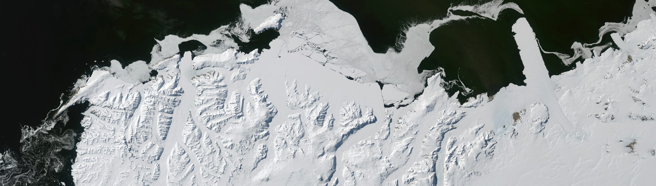
Antarctica's coast has a 400 mile north-south shore, where the mountains are arranged in dendrites, and glaciers are active but not dominant. To the right the David Glacier empties itself into the southernmost ocean via the Drygalski Ice Tongue, currently most prominent of the continent's tongues. Such seaward runouts are not as important an indicator as one would expect, because often enough a large iceberg will bump along the coast (nearly always westward) and shear off any tongues which may have been developing. The David is more famous for its pouring onto a coastal plain overdeepened in the past, via an intensely crevassed S-curve.
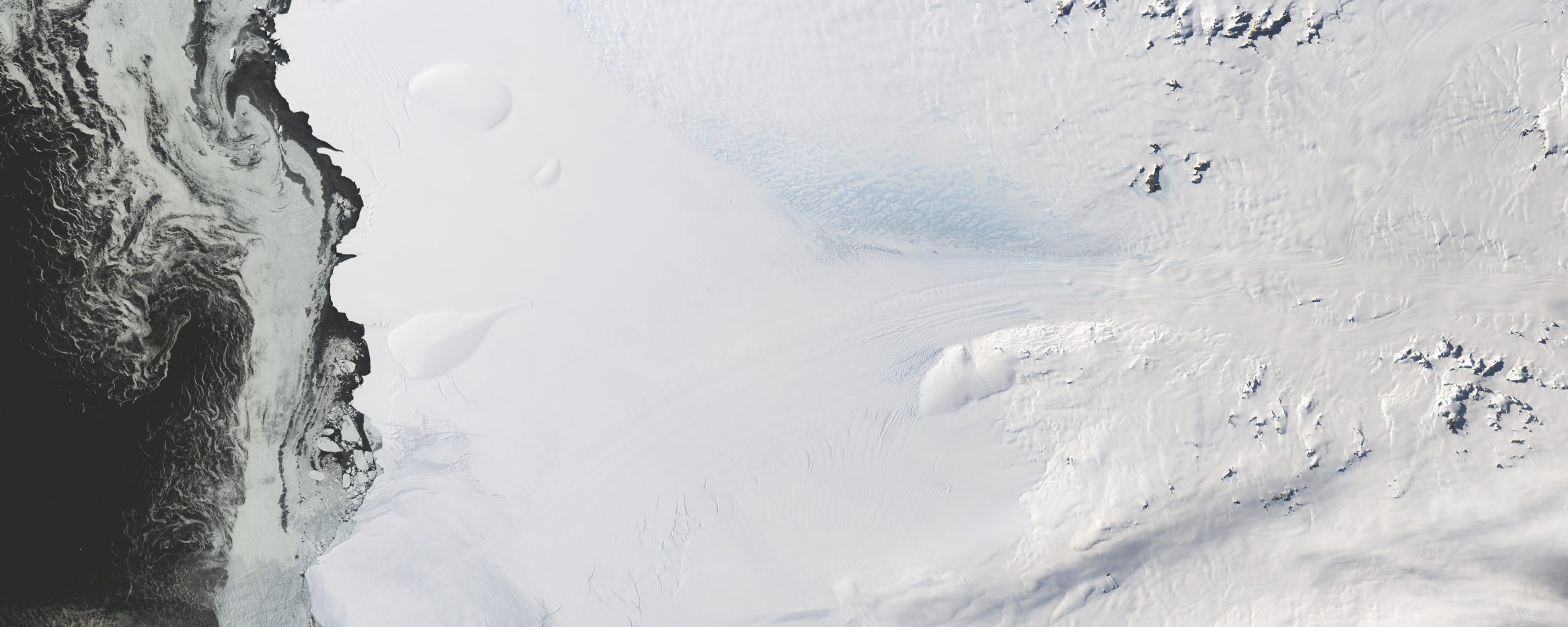
A typical shoreline has moderate shelfing, an island or two, and glaciers which barely express themselves in the flow features of the ice coverings. Distribution of offshore sea ice shifts on a weekly basis during the summer image season. The constancy of shelf edge breakage, or calving, is a surprising feature of the seemingly rock-solid continent (given our usual disregard for the unstoppable slowness of geological processes). Shelf edges are most often vertical and are 50-350 feet high, with the shelf's underwater depth typically much thicker, 500-2500 feet.
This highest of Antarctic mountains sits very near the Ronne Ice Shelf, on what would be the seacoast (in the absence of shelves - EXCEPT if they were melted then sea level would have risen, as would the bedrock without the weight of the ice). Offshore there are ice rises, which are subtle domes in the shelves where islands or shoal ridges have caused an upwarp in the shelved ice accumulation. These are visible in upper portions of the piece, and on other pieces in the exhibit - they often have a clean top angle, which seems artificial like a ghost fold during a paper airplane project on one's kitchen table.
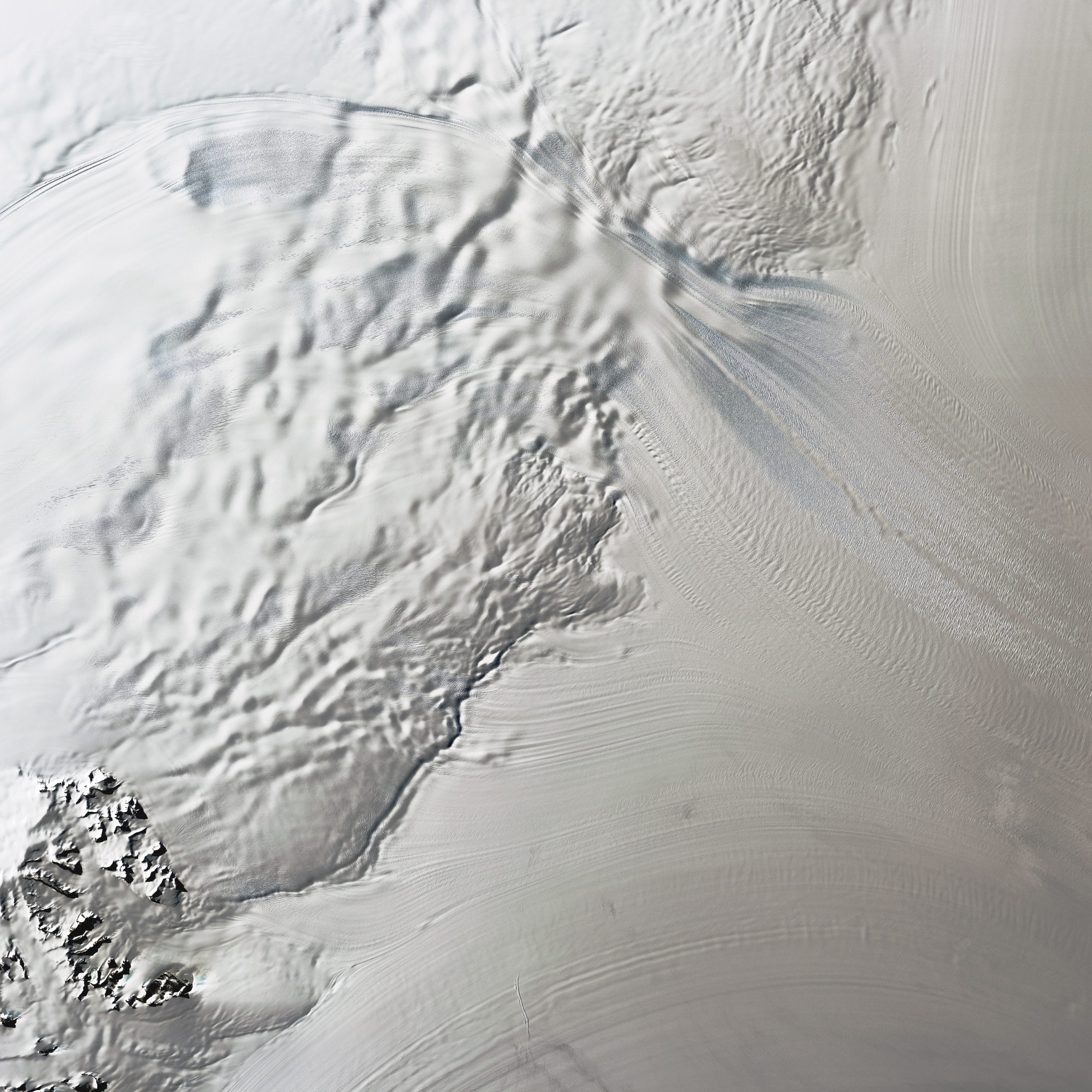
Unlike a glacier, where ice flows down a valley, an ice stream is a band of faster flow, sometimes vague in its extent, within a fluid icecap or ice sheet. Around Antarctica's central domes are many ice streams delivering vast flux to the coastal areas. One of the major streams is the Recovery, which is emerging here onto the Filchner Ice Shelf. The low sun angle shows how the main Stream extends onto the Shelf, joining other flow circulations as it approaches the ocean. The image is about 120 miles on its edge, and one can see that nearly all of it is moving. In general, the snow surfaces in this exhibit are nearly always in motion, and look blurred or unfocussed.
In Norwegian this means Giant's Stream, which flows around the western side of Queen Maud Land's thousand-mile chain of mountains (seen at upper right). The glacier has helped build the Fimbul Ice Shelf, a broad coastal shield which was visited in 1820 by a pair of Russian ships in the first human confirmation of the continent's existence. Blue ice has been windswept of its snow cover, and the low morning sun lays the heavy shadows of each upstanding peak to its west side.
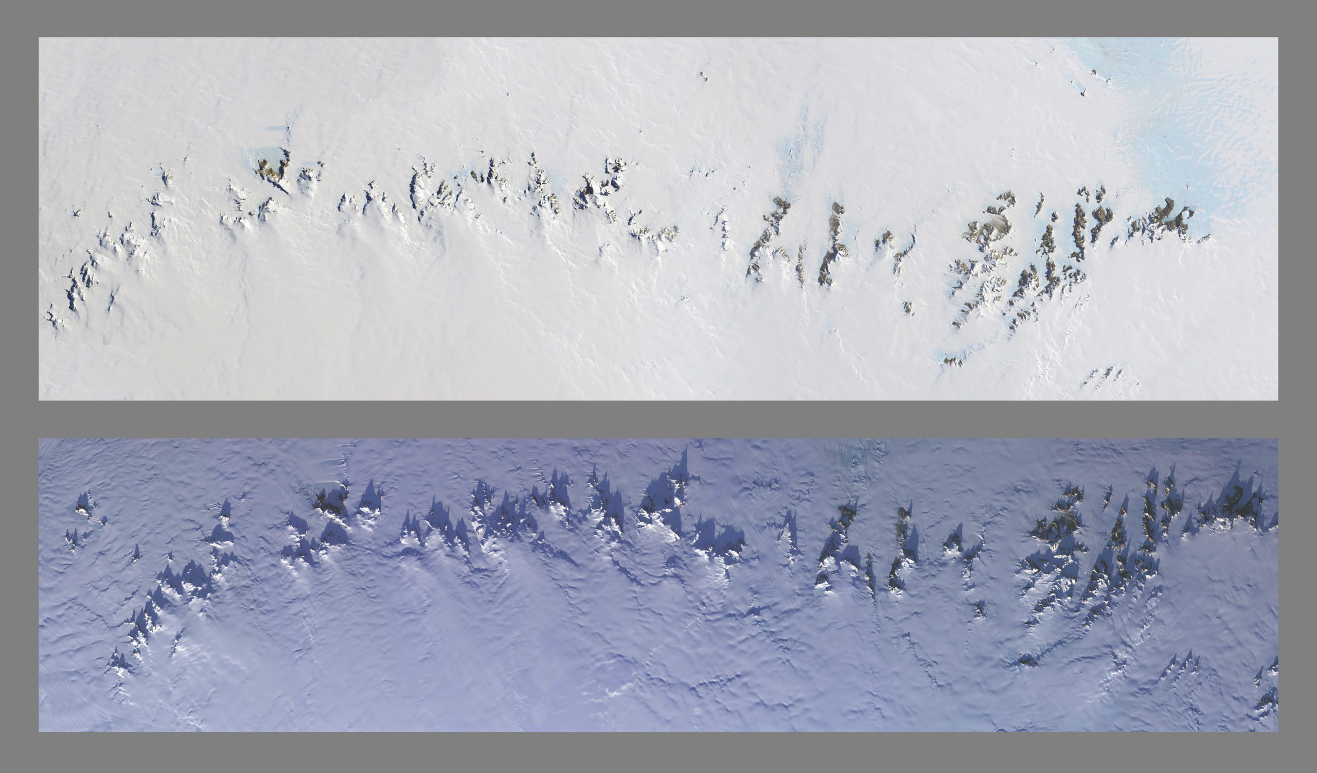
When we first learned of the Inuit word nunatak, it seemed that these were singular, here-and-there lonely mountaintops. But in the hinterland of the Africa-facing shore of Antarctica, these hundreds of nunataks are clustered closely and form some of the steepest and most picturesque of the planet's peaks. Holding back the gravity-driven spreading of the continent's ice domes, they form a picket fence whose inundation is more extreme from the south side than it is from the north; one can see ice piling up on the lower side, and occasionally the flow marks of glacial leakage through the gaps. And in the lower view, a midnight sun near summer solstice (from 5 degrees above the South Pole) casts shadows upwards to reveal each major peak's shape.
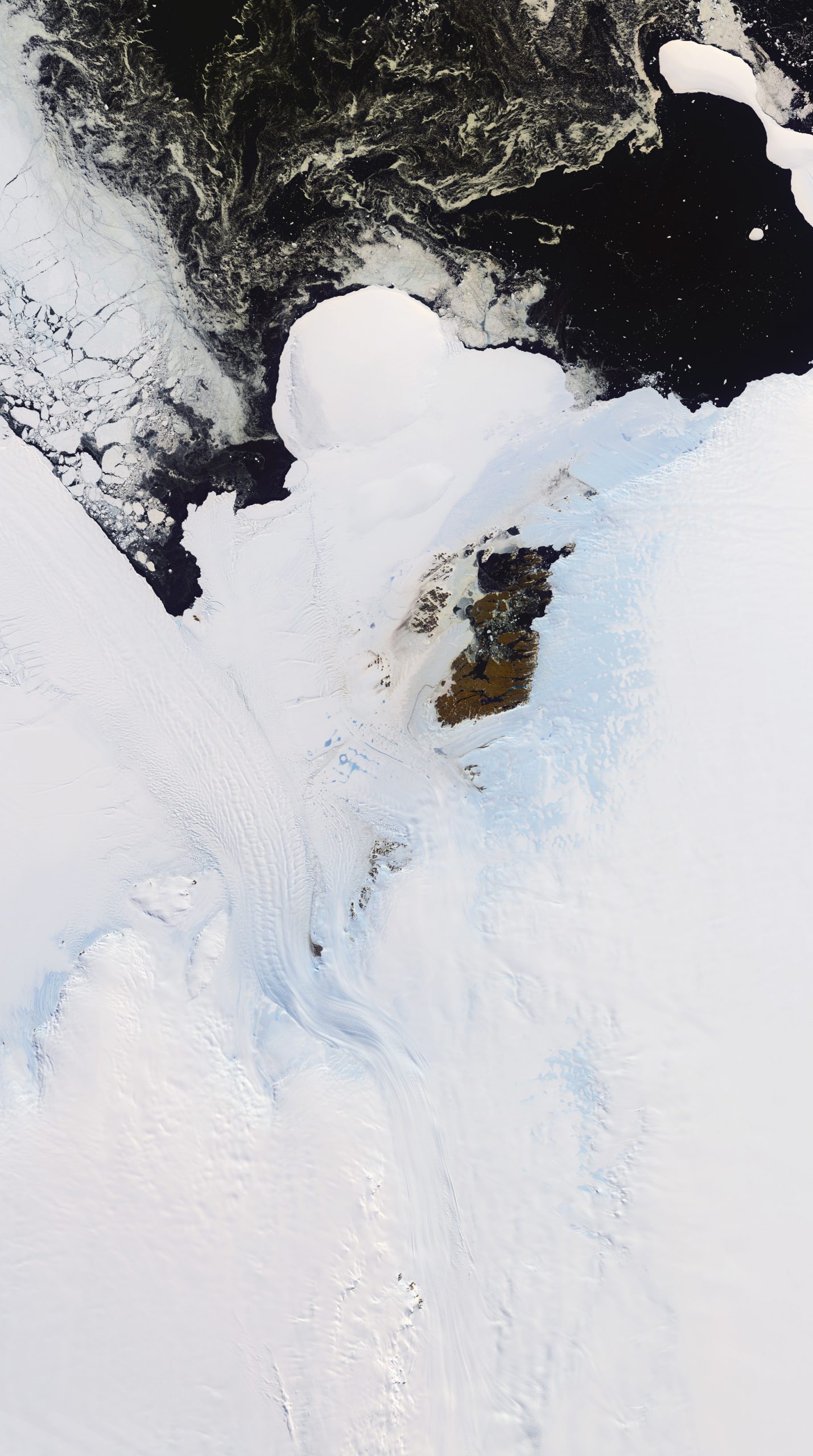
To the east of Queen Maud Land's mountain chains, the midsize Shirase Glacier enters a final twist as it approaches the coast. The presence of a confined channel causes an angular adjustment from the broader motions across more gentle terrain immediately upstream (remember that ice differs from water with its semi-solid rigidity). This redirection may be an important force for overdeepening, as so often there are small basins at the break of slope where iceflow is slowed by confining shelves or by bed irregularities. The ocean's warmth may flood these pockets and melt the confined glacier from below, thinning, calving and lubricating its passage. Here the shelves seem youthful with a wonderful scatter of locked-in but crisp-edged bergs. At mid image on the uppermost brown island is the location of a Japanese research station.
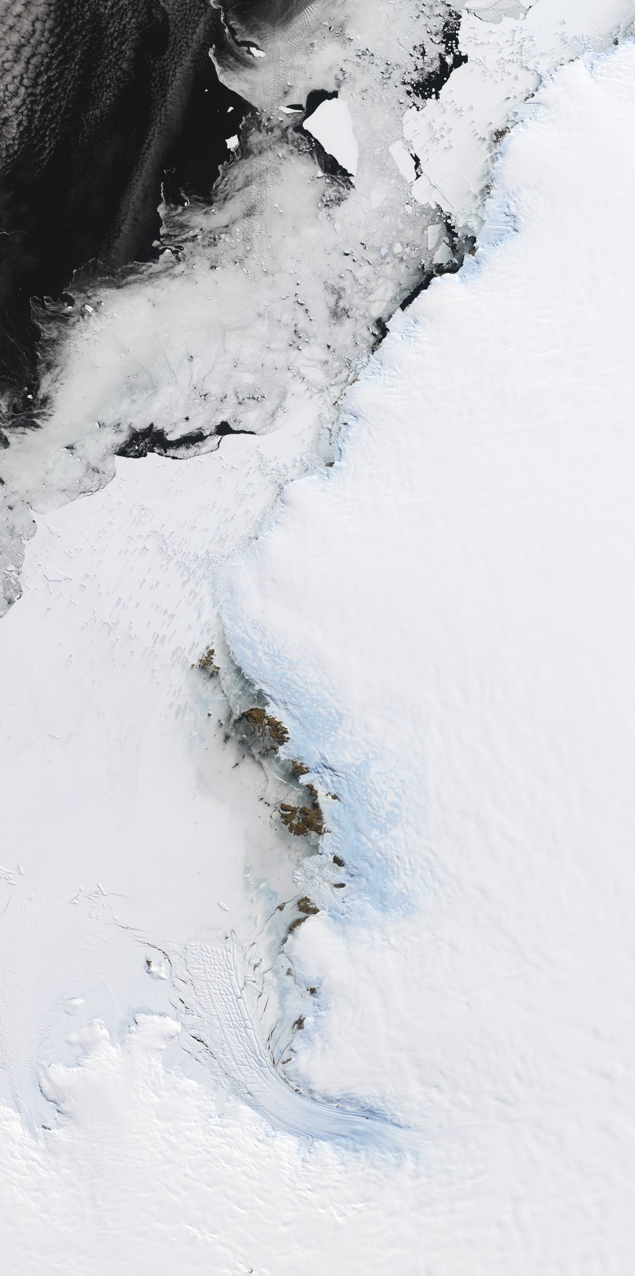
In East Antarctica on a longitude with India, this area is comprised of an enormous flow confluence – one of the planet’s largest. Near to the broad Mawson Escarpment is a huge overdeepened basin. Recently research has placed the glacier’s grounding line nearby, quite far from the Avery Shelf edge (250 miles). The Avery has a wedge-shape that is elongated, discouraging comparison with other shelves (the Ross and Ronne shelves are even more extended from their grounding lines but are less linear in their inflow geometries). There is evidence that the Avery may have receded upstream to the vicinity of its grounding line as recently as 5000 years ago. As it may rank very high in ice shed volume, the status of its protective ice shelf is important to us all.
The visibly-obvious ice pathway is the Denman Glacier, which twists or falls into an 11000 foot deep trough, the most abrupt local basin yet found. Ice curves reaching this feature are colored blue by the opening of yawning crevasses. Whether the sub-glacial basin contains seawater of substantial warmth is not clear, and its history is also a puzzle. Nearly as mysterious are the naked hills in the upper right. They seem to have been without ice for an extended period, and have lakes near the freezing point, both fresh and highly alkaline, sometimes as layers in the same waterbody. Sea level rise from possible unplugging of this glacial system may be in the top ten threats, most of which have an overdeepened approach to the sea.
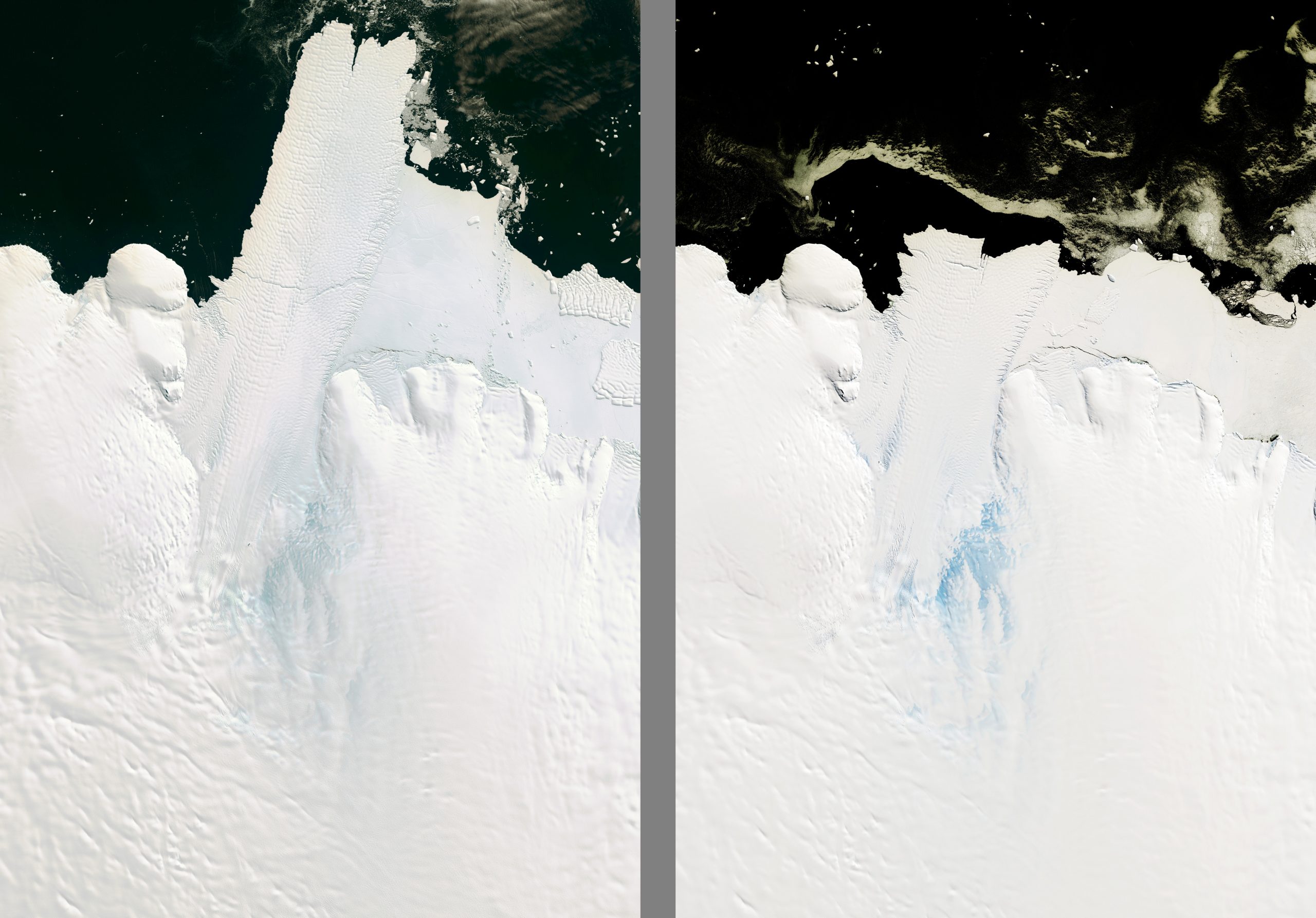
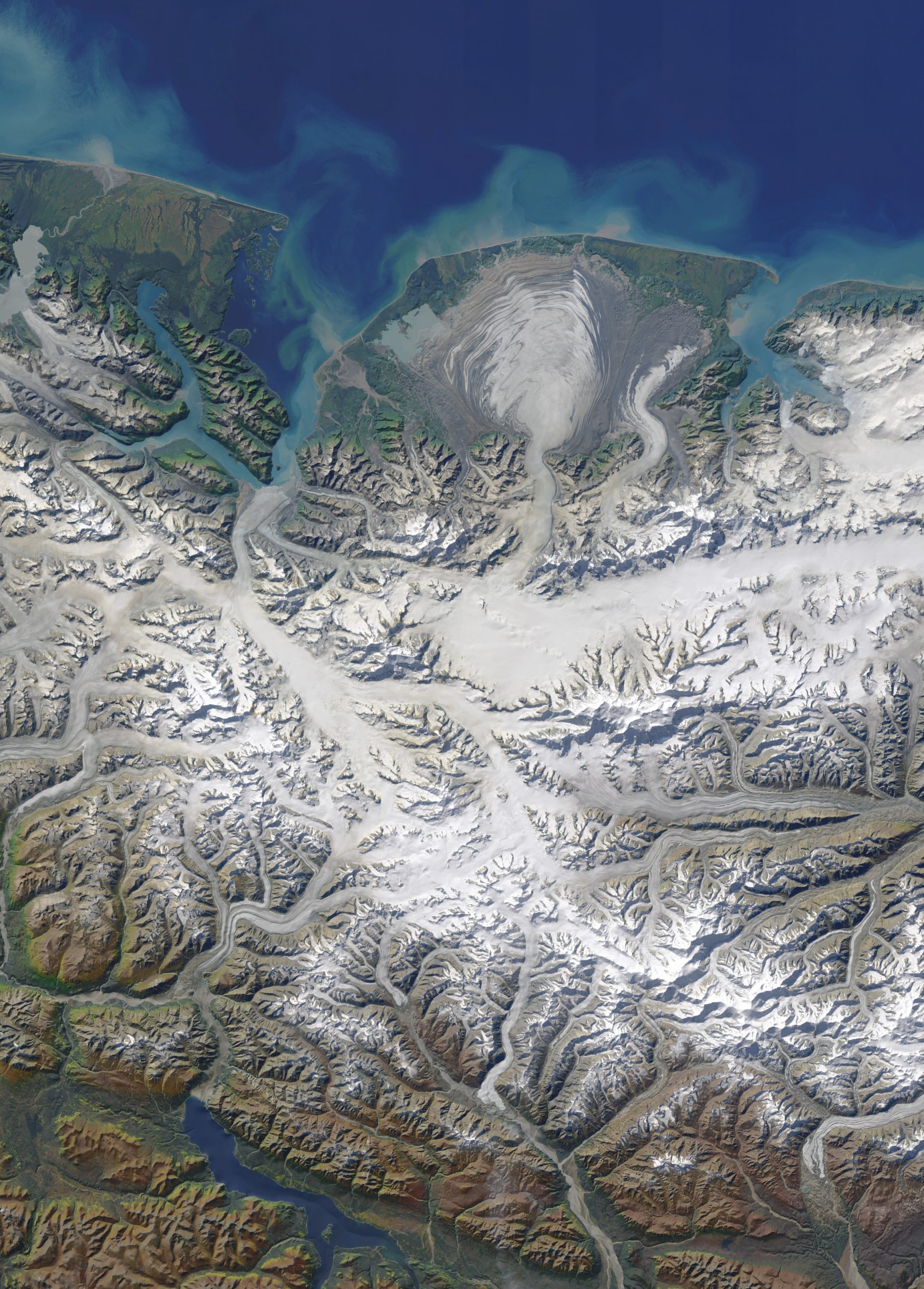
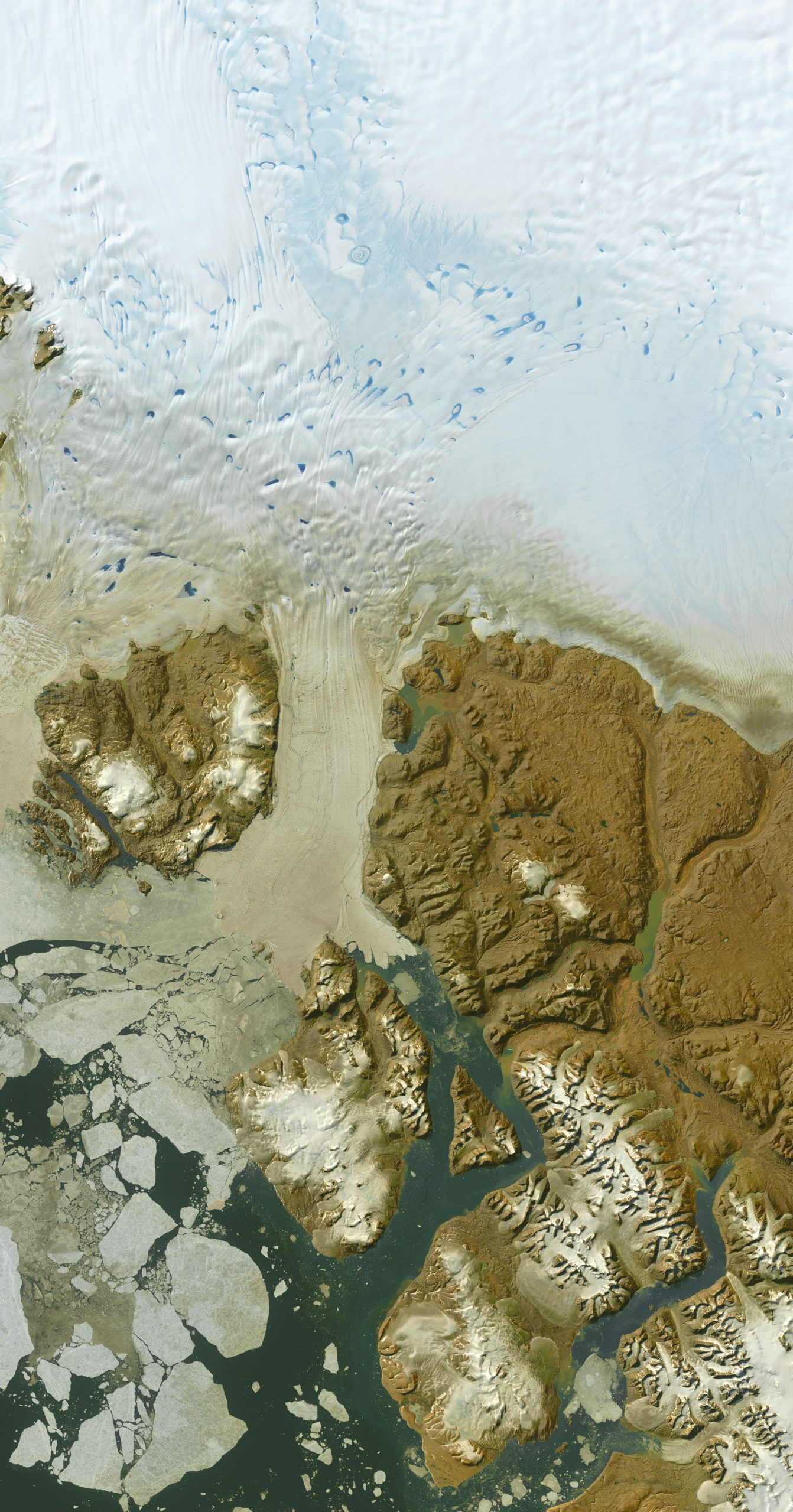
Two images from 2003 and 2016 show that an ice tongue tore off recently. Online search can find a movie of the collision with a fifty-mile-long iceberg making a twin of itself after having bounced a thousand miles down the coast. To help appreciate the scale of all this - the table of the calved tongue stood more than 1000 feet above water. The glacier may grow a new tongue during the lifetime of our youngest grandchildren. Looking lower to where the ice squeezes out of the bottom edge of the main ice sheet, it seems a cartoon diagram of a gigantic tunnel flow (like those that formed finger lakes around the world, but larger at 22 miles across). These are big systems, and it takes a lot to change them. A 1913 Australian expedition lost a member here named Mertz, who is truly now part of this grand dance.
As the Andes extend southward into the core of the temperate zone, cold and wet become the year-round rule: a perhumid climate is dominant. At the crest of the range snowfall is a very normal happenstance, and two icefields have developed: North Patagonia and South Patagonia, the latter being larger and likely to be longer lasting. The glacial troughs on the right side show amazing scars of overdeepening. As a mild-mannered surrogate to the perhumid Tall Coast region, this ice factory will likely be a laggard to drastic changes in more extreme environments (the Arctic has recently had more temperature rise than other regions).
Among nature's landforms, high on the beauty list would be finger lakes. Such glacier-dug troughs are found in dozens of regions, but this group in SW Alaska seems as fine as any other. They remain back of beyond to this day. Early human visitors to this continent likely bypassed them, but in the 19th century the era of exploration eventually led pioneers to this area's riches of fish and fur. Russians and later on Anglos were individually successful, but somehow the core of the area never drew interest (even to make a central name, at least in the map data available today). The peaks (called the Ahklun Range by a few sources) are only mildly glaciated, and those glaciers were studied 10 years ago (ice patches 90+ and falling, Northern Arizona University). It is in the areas less known that we will lose the most.
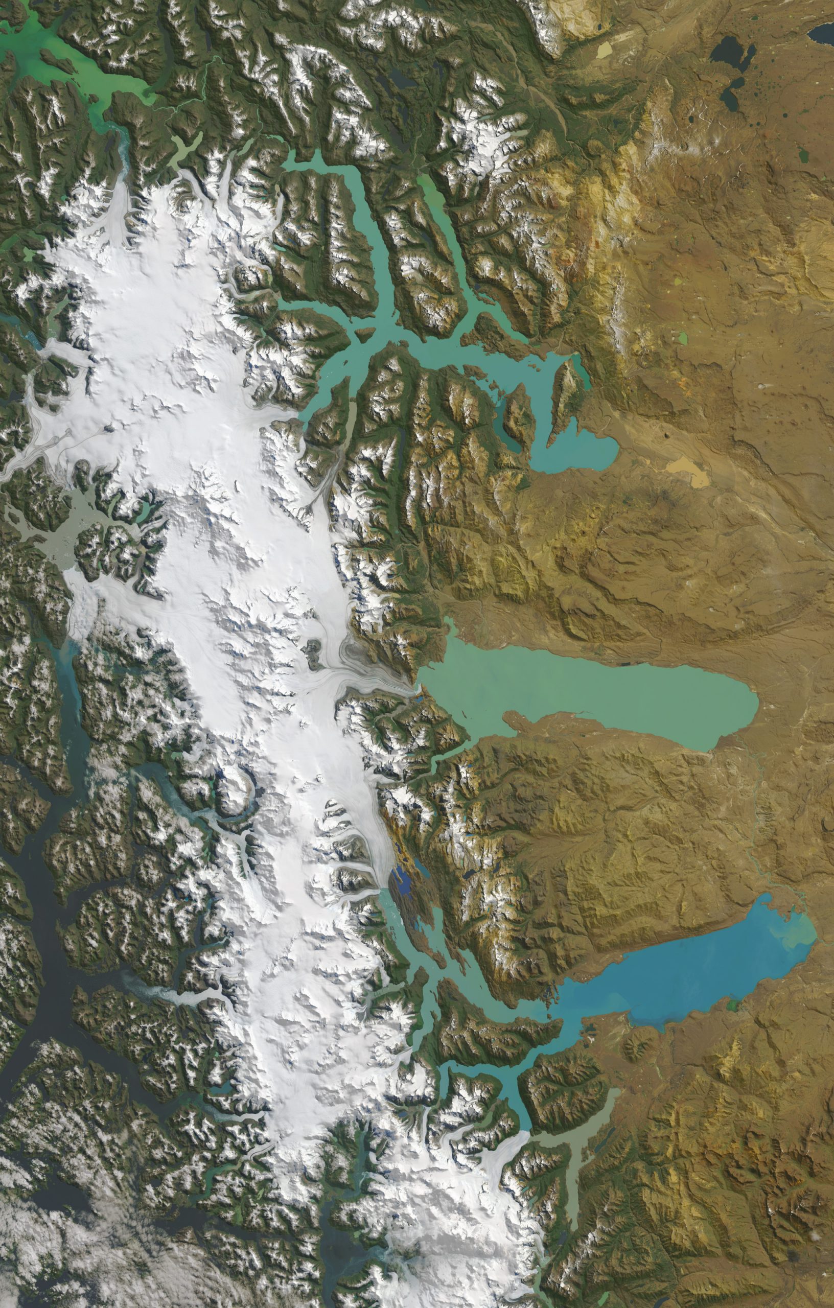
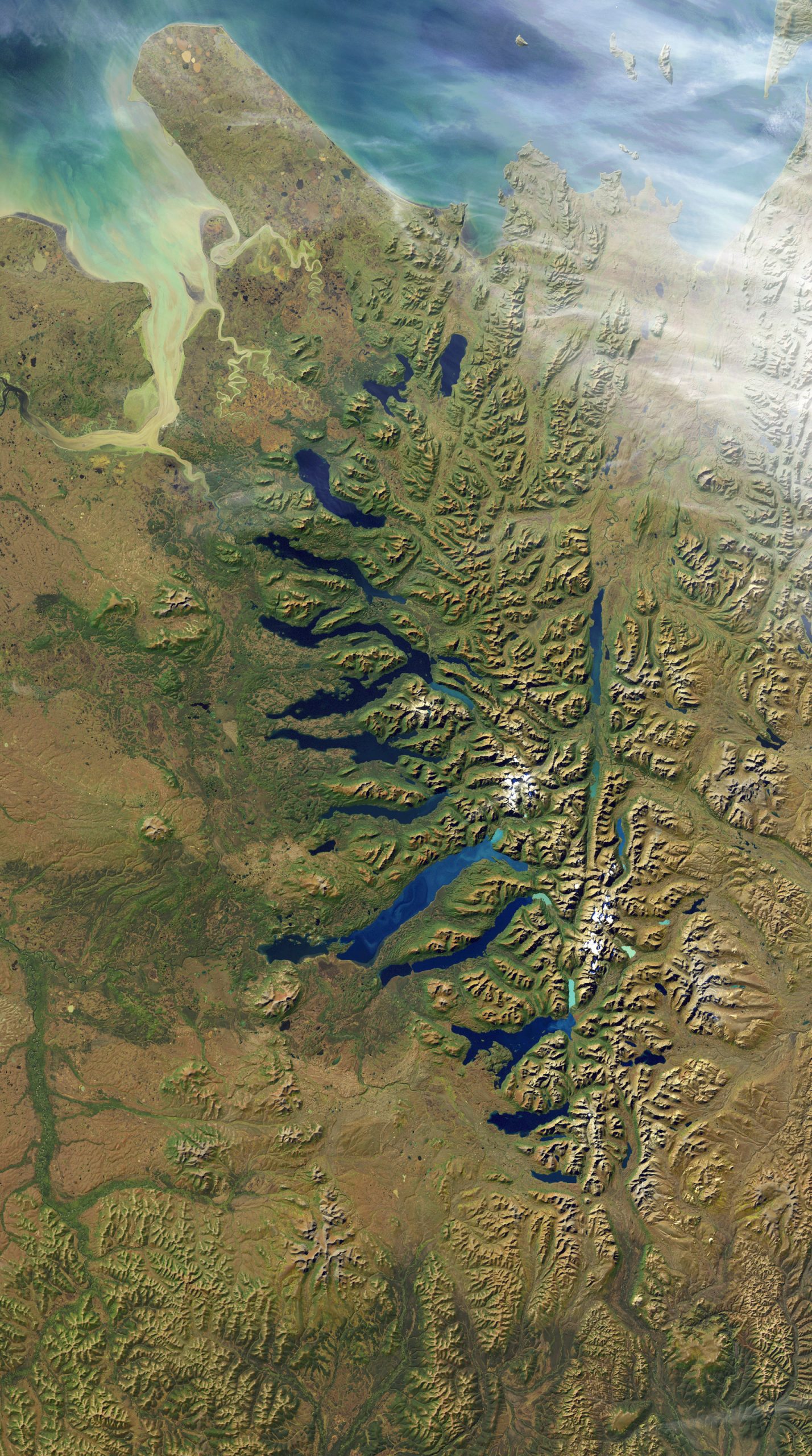
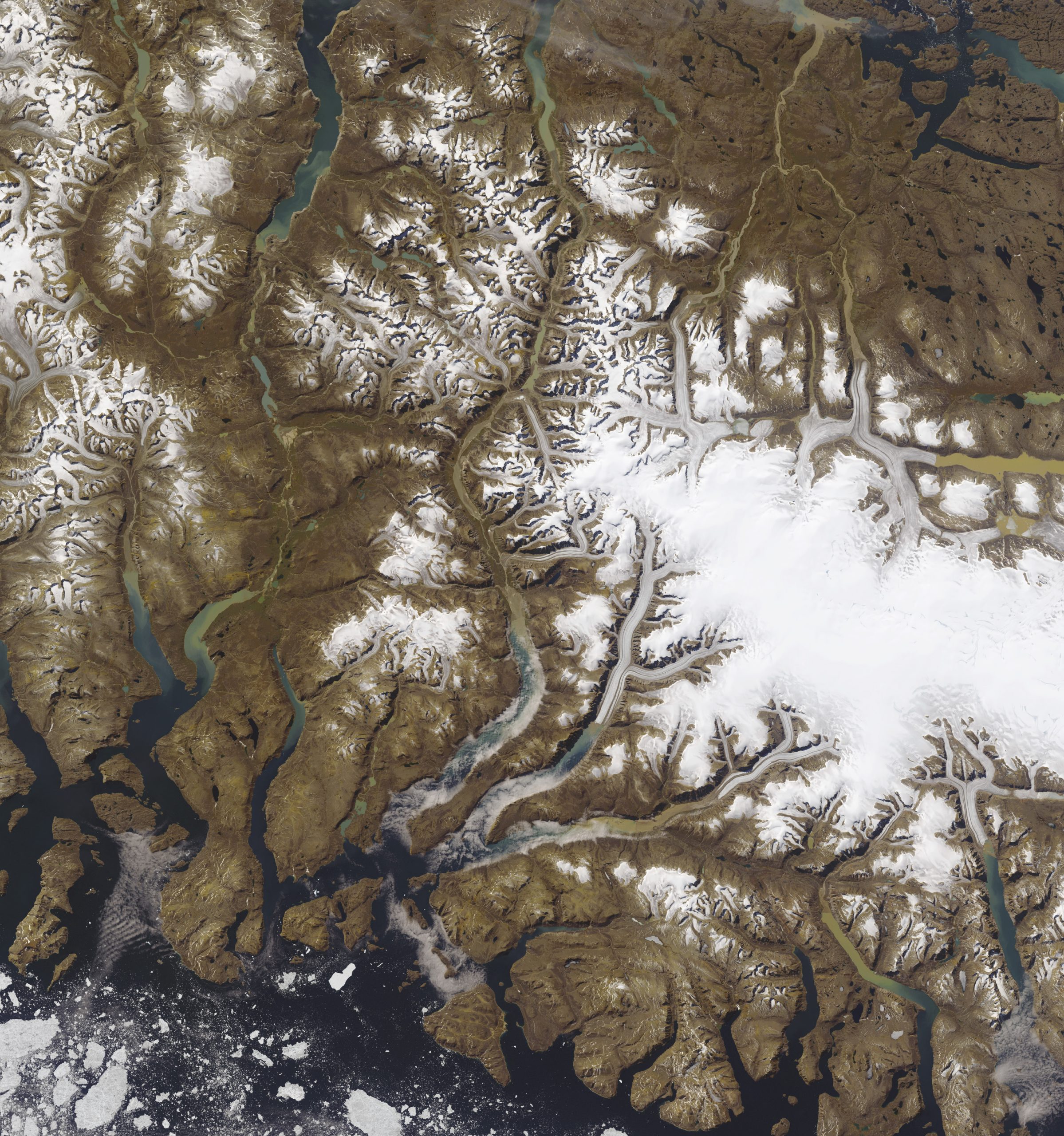
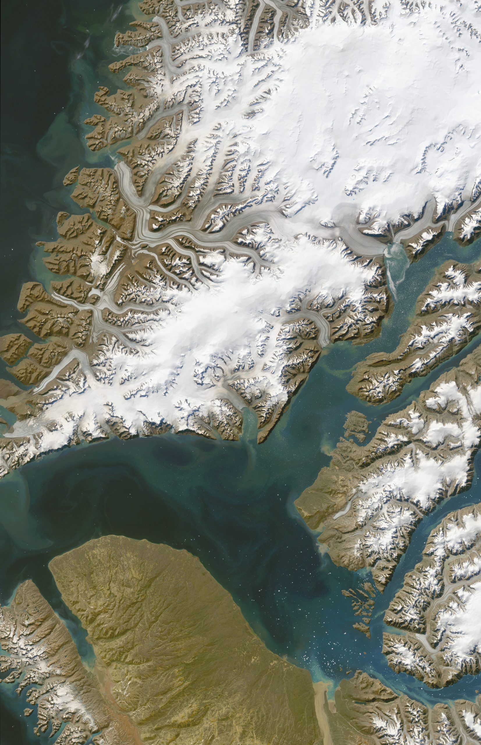
At the north end of the Alaska Panhandle these valleys fill with relentless rain and excesses of wet snow. In fact the top of Logan is a plateau so snowbound that its elevation (the highest in Canada) changes from year to year. Many of its subsidiary peaks fairly crowd the coast, and yield glacier features larger by far than any others on the continent. As highlands on the Arctic side of the temperate zone, these are unique due to their extreme height, their preponderance of cold rain, and their proximity to the ocean. At the head of the left (eastern) inlet of Yakitat Bay, the Hubbard Glacier repeatedly closes off the outlet of the large and always flowing Y-shaped Russell Fjord - one of the most famous GLOB sites currently active.
North America's east coast has a strong modifier in its offshore current, the Gulf Stream. Its warmth has lessened the effects of increasing latitude for many millennia in the last million years. There is strong evidence that the effect (and the current) shuts down at the onset of the cold portions of our cycle; it could be our saving grace in this global spiking of temperatures. Here in June 2014 is the north shore of Labrador, a fortnight away from the summer solstice, with a light covering of fresh snow tracing every rumple. Straight valleys were born of meltwater draining from the continental ice dome to the west, across a hard and probably ice-leveled rock surface. The prominent lake of the title is a 35 million year old impact crater.
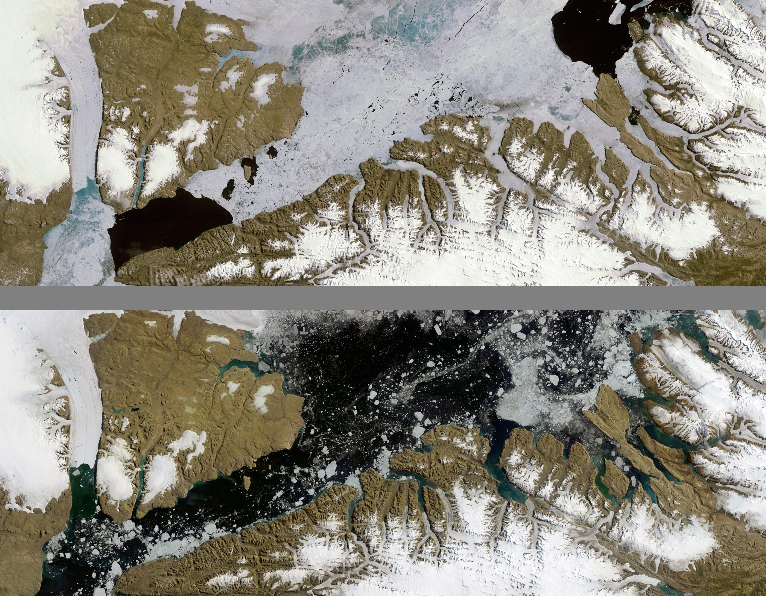
The 19th century flurries of arctic explorers were said to be mostly seeking the Northwest Passage. Sea routes over the top were indeed tempting and nearly feasible. Not much was known of island and inlet geographies, and many lives were lost to the pursuit of fruitless search. In our satellite age we now know that it was all for naught - until very recent warming, there were no gaps in the persistence of ice accumulating eastwardly in the Arctic Ocean against the west sides of the continent's northern archipelago. Even icebreakers had a hard go for 95% of the attempts until millennium's turn. Now a cruise ship has made it through; in another decade commercial calculus may be worth the risk. Then many things will change locally in the north. This beautiful cluster of islands is close to the shipping lanes to be.
Here is located Canada's most famed Northern national park, Auyuittuq. Unique landscapes fill the eye with improbable combinations of bare rock slopes and gentle vales. If the world needs a lab to figure out how glaciers carve mountains, there is a good one here. More than a hundred troughs are edged by cirques in their final stages of meltout, leaving horns and knife-ridges of amazing diversity. Through-valleys mark the placement of the main avenues of ice escape, while the remnant Penny dome asks the curious what marvels await its further retreat. The area is a model for what will be found in the mountainous parts of Antarctica's buried topography.
In the middle of Baffin Island is this 20000 year old remnant of our last North American continental ice sheet. It is more melted than nearby icecaps, perhaps telling that its position used to be more of a cold locus than it is under today's climate. The fine exposure of ice layers and corduroy gullying on its steepest slopes are more pronounced here than anywhere else, at least over so large a feature. There are collapsing smears along its upper (south) margins - showing mud overflow and an oscillating fringe of meltwater deposits. Unlike the smaller iced ranges near the coast at the bottom (with their puddled terminal ponds), the Barnes Icecap remains intact but shrinking, like a hardened place in decline.
This complex area includes nearshore fog-bank climates and the always windy and frozen crests. Like the Barnes it is giving way to warming fastest on its south (right) sides: outlet glaciers bulge with blended rocky content, and even are pushed to the threshold of making smaller, less cohesive outlets, as if a warm week or month had triggered something different. There is much to learn and little time to mull it over. The icecap is well known (radar has measured its layers), and while it may survive for some time, it soon will be a beanie of its former self. Its importance lies in what it can teach us now, in the throes of its disappearance. We'd be better off to know its lessons.
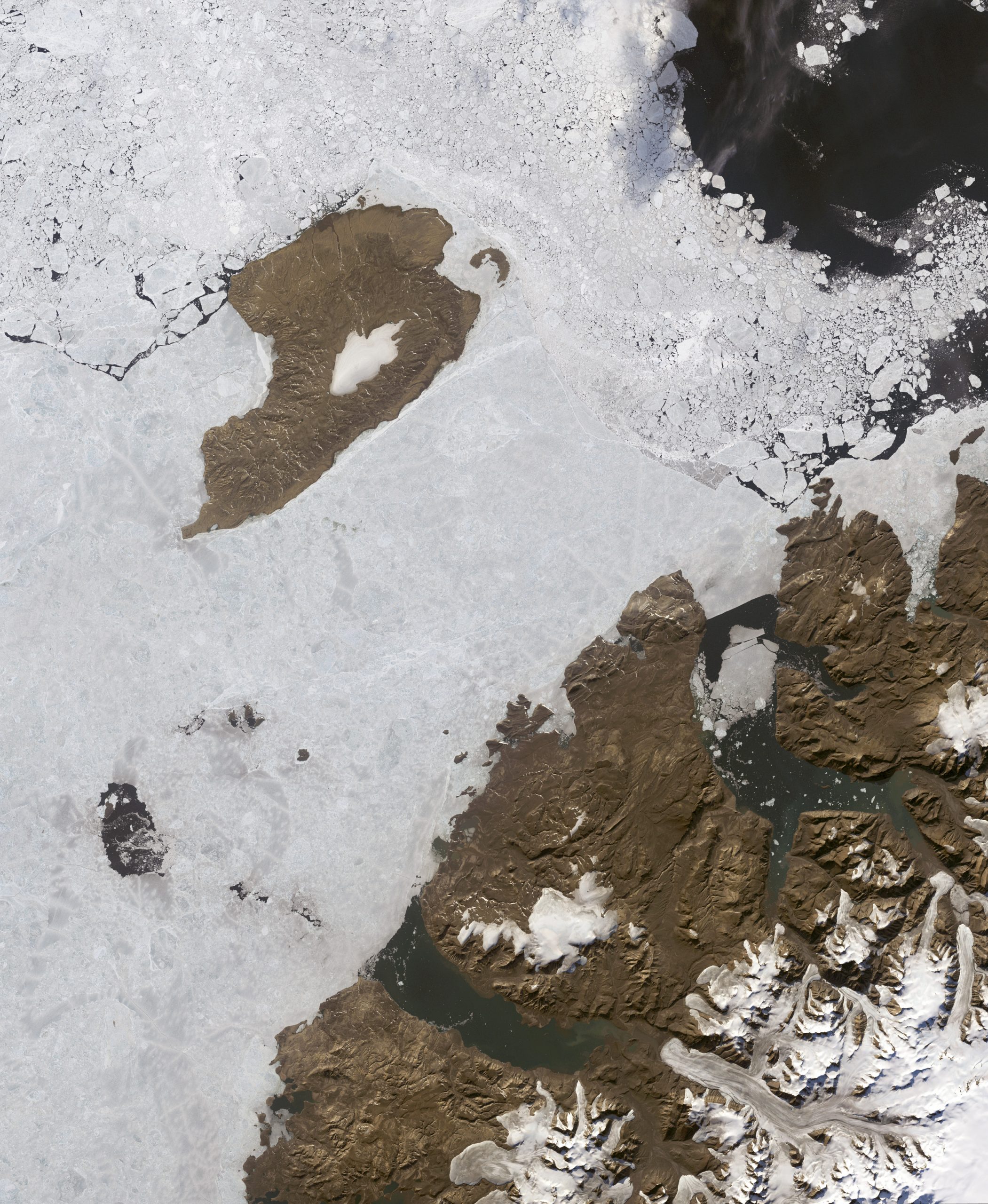
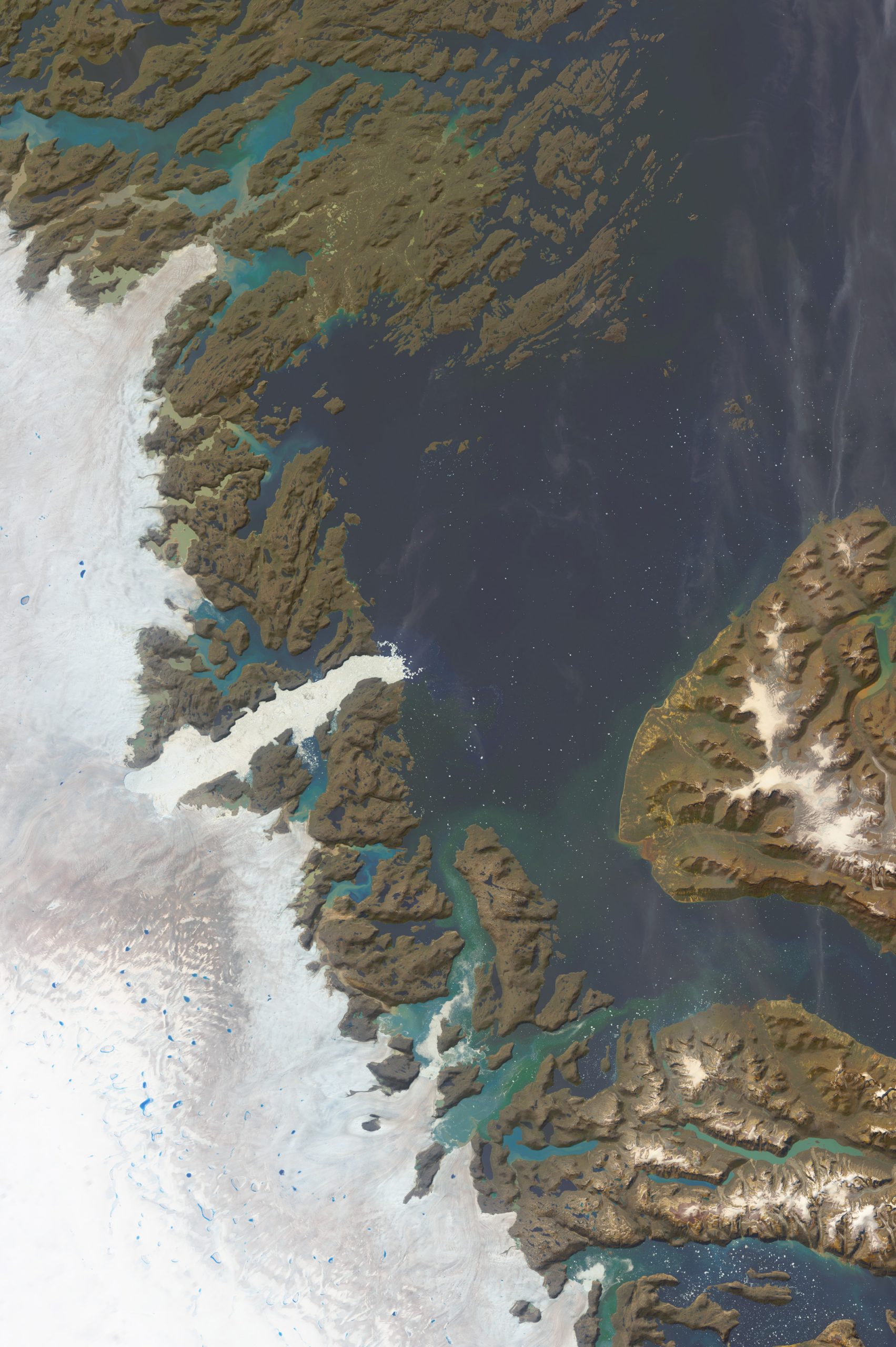
The little island, Meighen, has a small icecap which is naked of snow cover, like the Barnes. Its big neighbor at lower right, Axel Heiberg, is shedding ice without pushing it into the sea. In many spots ice is thinning and likely sublimating on the coastal plain. This melt scene is happening despite the short summers of 80 degrees north (it is the south edge of the Arctic Riviera on the west shores of Axel Heiberg and Ellesmere Islands). In a different era this was a snow (and glacial) center as shown by the very thick troughs of the fjord areas. The whole of the Arctic Ocean circulation has recently been collecting sea ice in this area, more so than for any other set of Arctic shorelines.
This most famous of Greenland glaciers is responsible for about half of the icebergs that perturb shipping lanes between Europe and North America. It is a classic tunnel glacier, in that it collects itself from near the bottom of the ice sheet, and emerges near the margin as a mature flow. In this century Jakobshavn’s calving front has been retreating backward while the whole glacier is flowing forward at record speed. It has a unique position within Greenland's bedrock topography - there is a central basin with few sea level outlets, and this outlet is closest to the ice sheet dome. However, this glacier has been pumping ice into the ocean more quickly than any other for a long time, and may not be a responsible force for sea level rise. Its hose has been open and accounted for already.
Among hundreds of named outlet glaciers of Greenland, this is the second with a direct bed-path to the sea, via a curiously long and sinuous sub-ice canyon. It has the added threat of an extremely overdeepened final section before the coast, perhaps allowing catastrophic acceleration to occur from an unplugging event brought about by the rise of oceanic temperatures. Each glacier has a balance of flows with back- and side-pressures, but it is unknown territory to imagine what secondary or tertiary effects may happen when major equilibria are lost. Where will the planet's ice begin to lift sea level to damaging extents? Likely it will be much faster and less predictable than we would expect. This glacier has lost its floating snout (in 2010), its outlet area is now clear of sea ice most years, and the nearby small land-ice features have thinned and shrunken, but none of this is itself cause to panic. The flow is steady, and while the ice sheet’s melt continues to lose vast volumes on a yearly basis, the runoff situation has not yet turned ugly.
A European prince gave this glacier its numerical name because its most obvious surface-flow sections cross the north seventy ninth parallel. It is the third big Greenland outlet glacier to have an open low elevation pathway to the sea - with the longest route and perhaps the largest ice shed. From the top of the ice sheet to its extreme NE calving front is ~ 550 miles distance. Nearly all of its energy derives from its southern sections, as the NE area is a cold desert, the driest part of the island - note how dust from the nearby bare land coats and discolors the ice surfaces as they approach the coastal terminus. There are substantial overdeepenings in this area, but research has not yet determined their significance.
Midway along the east coast of Greenland, this huge fjord is a vestige from more icey times. It shows that Greenland was once closer in character to Antarctica than it is today. The region to its south is called the Blosseville Coast, after an 1833 ship's captain who happened upon it, was intent on its exploration, but first sailed to nearby Iceland for ship repairs - and then was lost here with a complement of 83. The glaciers are sinuous and filled with medial moraines, with many branches feeding a final trunk called Dendrit.
North from Iceland 350 miles, still warmed by the Gulf Stream, this 30-mile spoon of an island has an active volcanic cone with glaciers on its flanks. One of them falls 7000 ft from the main crater - as a straw man for having one glacier to watch. It is warmed by eruptions, has wild storms in broad oceanic surroundings, and is unlike the typical case of flowing ice on this planet. Easy to keep track of, but its fate would be less diagnostic than hundreds of other choices. Part of the exhibit’s message is that the planet is vast and varied, and it needs to be measured here, there and as close to everywhere as we can afford. Public sector and academic institutes will be the handlers of these chores for us. We must invest in these researchers, and also pay enough attention so that they do a good job.
If we need to identify a single feature, then the danger point of the moment is here (focus will likely soon shift, and the story will become more rooted in the collective effects). For now the Antarctic Glaciers of Pine Island and Thwaites (its western neighbor to the right) have by far the largest outletting on the continent, and their bed geometries and recent climatic trend predict acceleration. Thwaites is a huge medusa (80 miles wide) whose nearby parts (its right bank) have been the site of a 3-year gouging 2017-19 with vast size (Manhattan Island's area and depths over 1000 feet) - proof that the over-deepening tendencies continue today. For a compendium on what is happening and how the science is keeping up, antarcticglaciers.org has clear if not thoroughly current explanation.
These two arctic outliers to Siberia are ice free each summer, and they are simple places with no accumulations of snow, or of meltwater. They have little to suggest to our climate change debate, except that there will be an earth at the other end of it all - it will look something like this. There may not be many humans around to enjoy it. Some population may move to livable habitats which are currently buried under domed ice - the Queen Mauds or Gamburtsevs in Antarctica, or the Blosseville Coast or Axel Heiberg in the Arctic. A supply of water is critical, among many other hard-to-meet needs. If we can mitigate a bit, we may survive in some way.
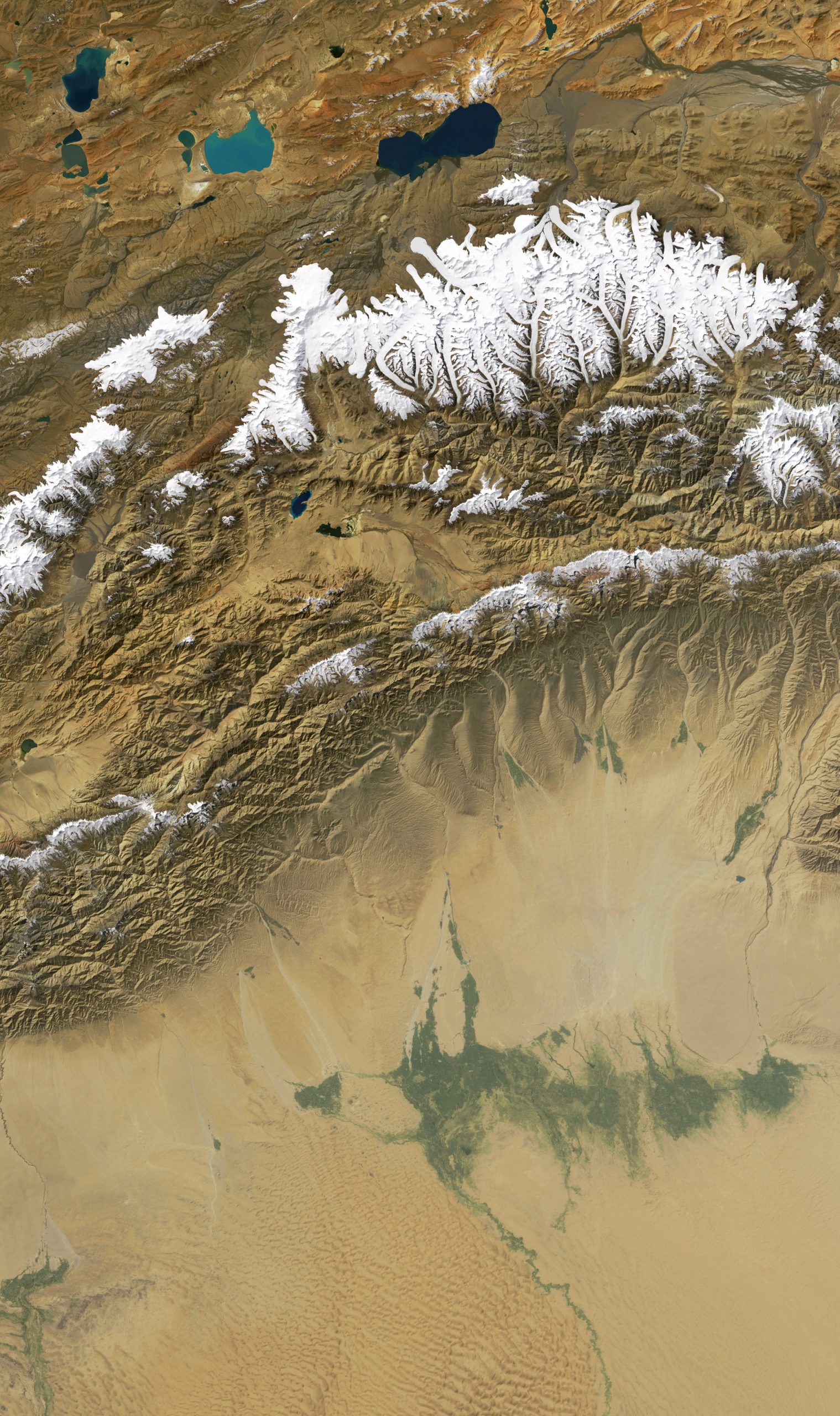
The final section is sited in Asia, where our growing-huge populations are so dependent upon a system of water-borrowing; highlands are subsidizing massive communities in the adjacent lowlands via now-ever-more-erratic river flow. One surmises that very tall mountains are better as source areas for these systems, but often the more moderate terrain yields better results. Using area above 20000 feet in the case of Kunlun, the ice-covered cluster straddling 81° east, called Kunlun Goddess Range, is 4 times larger than the area around Everest, and 12 times the size of source areas near to the Kali Gandaki gorge in central Nepal. All of them are paltry compared to the storages of high latitude.
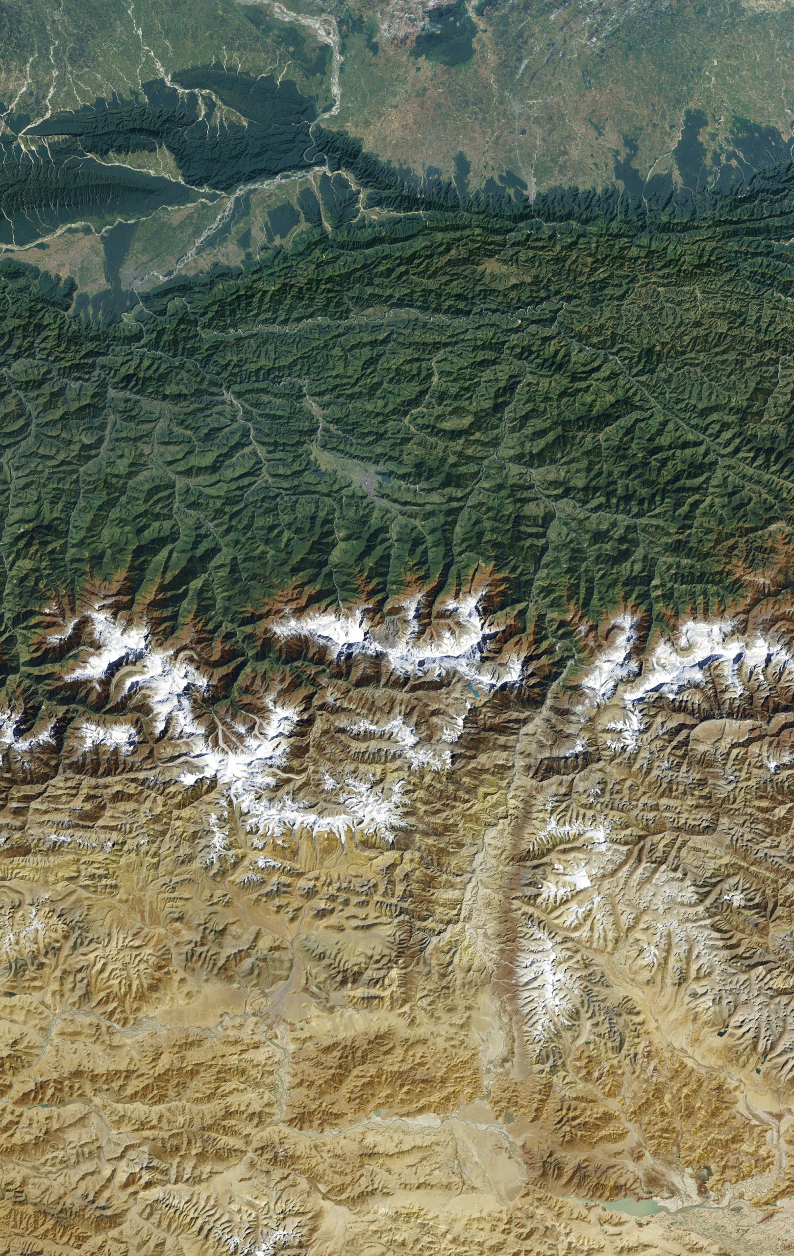
In the Himal near to New Delhi, these valleys and ranges with pilgrimage sites usually see about one million visitors per year. A sacred ice tunnel where the Ganges is said to begin is joined by five confluences of adjacent streams, and is overlooked by broad meadows, sharp peaks and many temples of nature and humanity. To a thorough degree the reality of water giving life is worshipped in the most populous and diverse landscape on the planet. We are fortunate to have this broadly-held sense to build upon, and perhaps a commitment to climate mitigation is doable if politics can be overcome. For centuries the data of river levels and discharge have been treated as state secrets in Southern Asia and in many other water-stressed regions. Time is knocking on our door to manage differently.
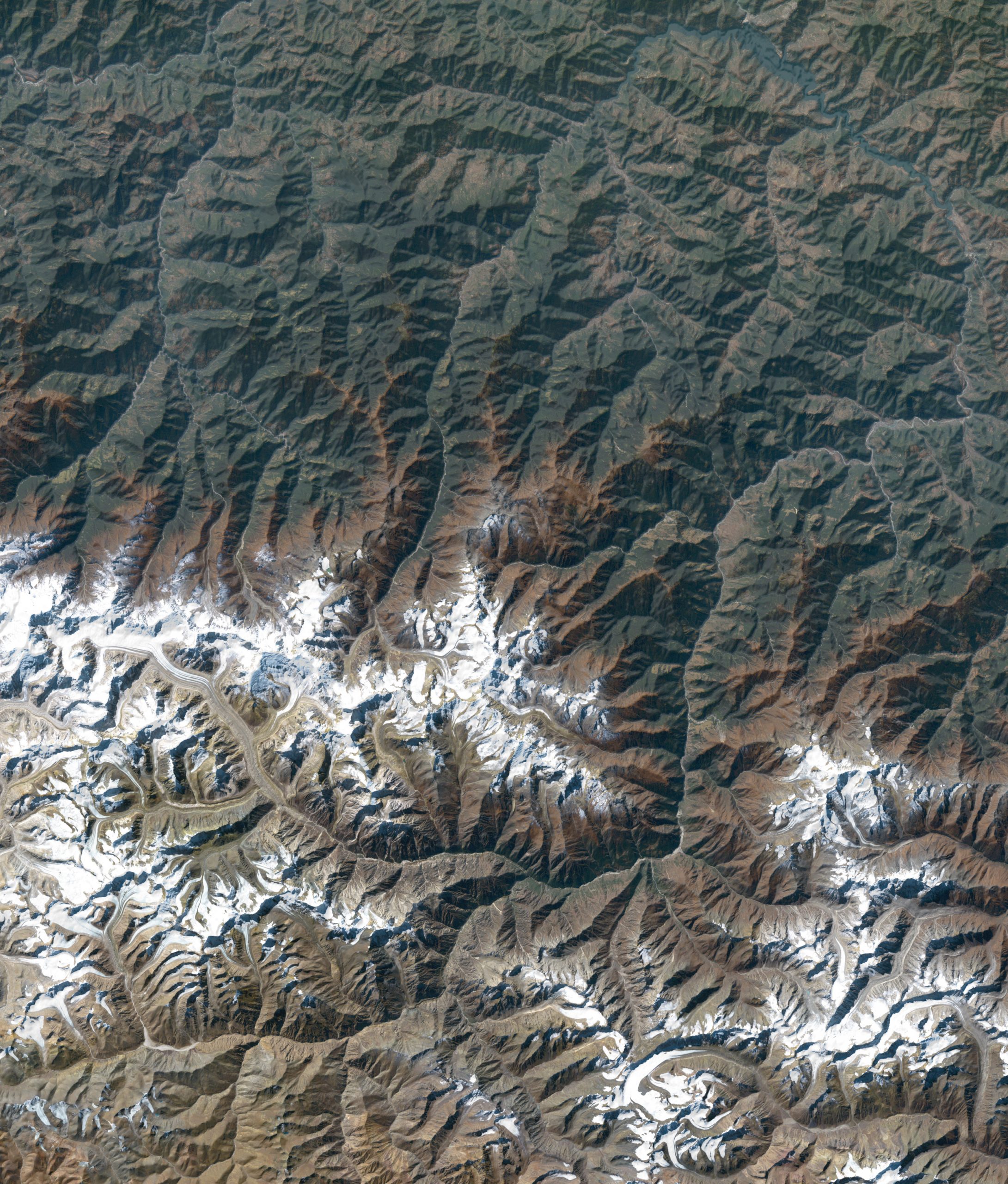
Three hundred miles eastward along the Himalayan front there is a major Nepali valley, the Kali Gandaki, which cleaves the high ridges and provides easy passage into the plateau realms of Tibet. The massifs of Annapurna and Dhaulagiri stand to each side of this deepest of valleys. Their glaciers feed many millions in Bihar and Uttar Pradesh. The local Thakali culture is traditionally conservation-oriented, with each tree to be utilized according to a council of elders. But they could be the first water subsidy source which will enter bankruptcy. Such might fall instead to the Kosi farther east, or the Colorado in the US, or the Parana in Argentina, or it almost doesn’t matter where. No one knows the answer, but there is plenty of impending chaos which will arrive before the seas take our coastal cities away. To be even a little prepared is a good idea.